
选修9
Unit2
http://www.tingroom.com/upimg/allimg/091013/0A21944K-8.jpgSailing the Oceans 课堂教学设计" />
1. Marco Polo
马可.波罗
2. latitude n. 纬度
3. voyage n. 航海,航行
A
journey by sea to a foreign or distant land.
航海:去国外或较远地方的海上旅行
4. mercy n.
仁慈,宽恕,怜悯
They showed little mercy
to the enemies.他们对敌人毫不怜悯。
We were treated with mercy.我们受到仁慈的待遇。
It is a mercy that you did not go.你幸好没有去。
5. at the
mercy of 受……支配
have mercy on [upon]对...有怜悯心
have sb. at
one's mercy使某人任凭自己摆布
6. encyclopedia n. 百科全书
7. alongside prep. 靠着,沿着;adv. 在旁边,沿着边
8. exploration n. 探险,探测
9. munimum adj. 最小的,最低的
10. celestial adj. 天上的
11. pole n. 极地,柱,杆
12. equator n. 赤道
13. horizon n.
地平线,视野
the horizon of knowledge知识范围
Science
gives us a new horizon.科学使我们大开新的眼界。
14. overhead
adj. 在头上的
an overhead bridge天桥
an overhead railway高架铁路
15. seadweed n. 海草,海藻
16. nowhere adv. 无处
17. offshore adj. 离岸的,海面上的
18. outward adj. 外面的,向外的
19. tide n. 潮,潮汐,潮流,趋势
Time and tide wait for no man.[谚]岁月不等人; 天道不可抗。
the tide of history历史的潮流
20. secure
adj. 安全的,可靠地;确信的;一定的:
Her jewels were secure in the
safe.她的首饰在保险柜中万无一失
Only one telephone line in the embassy was
secure.大使馆里只有一线电话没有被窃听
With three goals in the first period they had a secure victory, but
somehow they lost.在第一节他们进了三球,原以为准赢无误,孰料最后还是输了
The troops secured the area before the local
people were allowed to
return.在百姓返回之前军队负责保护这个地区.
确信:使肯定;确保:
Despite making several good jokes, he could not secure the goodwill
of the audience.尽管他说了几个有趣的笑话,但是仍无法确定观众是否接受他
be
secure from harm不致受到危害
be secure of victory有必胜的信念
Is this ladder secure?这梯子稳固吗?
He hoped for a secure old age.他希望有一个无忧无虑的晚年。
By
strengthening the river banks, the city secured itself against
flood.由于加强了河堤, 该城可确保免受水灾。
He secured the doors and windows.他紧闭门窗。
She has secured a good
job.她已获得一份好的工作。
惯用法:
be
secure against [from]没有遭受...的危险
be secure of对...有把握, 确信
feel secure about [as to]对...(觉得)放心
secure (sth.) against [form]使(某物)免遭
21. knot
n. 节 vt. 打结
22. log n. 原木,木材
23. nautical adj.海上的,航海的
24. nautical mile 海里
25. mangnetic adj. 磁的,有磁性的
26. bearing circle 方位圆
27. random adj. 任意的,随便的
at random
没有统一、计划、方法或目的的;结构混乱的:
chose a card at random from the
deck.
从一副牌中任意选出一张
28. astrolable n. 古代的天体观测仪,星盘
29. awkward adj.
难使用的,笨拙的
30. reference
n. 参考
have
a reference to和...有关
cross
reference to互相参看
give a
reference to提到, 介绍
in reference to关于
with reference
to关于
31. quadrant
n. 象限,四分仪
32. precise adj. 精确的,准确的
33. simplify vt.
单一化,简单化
complicate v.
(使)变复杂
complicate
adj. 复杂的, 麻烦的
34. portable
adj. 轻便的,手提的,便携的
35. shortcoming n. 缺点短处
36. sextant
n. 六分仪
37. update
vt. 更新
38. tendency 趋向,倾向
have a tendency to [towards]有...的倾向
39. reliable adj.
可靠地,可信赖的
It is reported on reliable authority that 据可靠方面消息...
40. Samuel 塞缪尔
41. swoop vi. 突降,猛扑
42. parcel n. 悬崖,峭壁
43. peck vt. vi. 啄食
44. cliff n. 悬崖,峭壁
45. expedition n.远征
46. compulsory adj. 必须做的,必修的
47. reform n. 改革,革新
48. survival n. 生存,幸存
49. Captain Bligh 布莱船长
50. △Tahiti 塔西提岛(位于太平洋)
51. incident n. 事件,事变
52. departure n. 出发,离开
53. crew n. (轮船、飞机等上的)工作人员,(工作)队
54. deposit vt. 放,(把钱)存入银行
55. dilemma n. 进退两难的局面
56. drawback n. 缺点,障碍
57. dusk n. 薄暮,黄昏
58. routine n. 常规,日常事务
59. reckon vt. 计算,估计
60. reckoning n. 计算,估计
61. starvation n. 挨饿,饿死
62. psychology n.心理学
63. tesion n. 紧张,不安,张力
64. gradual adj. 逐渐的,逐步的
65. foresee vt.
预知,预见
66. thirst n. 渴,口渴
67. Timor帝汶岛(位于东南亚)
68. set losse 出发,开始
69. tear vt. 扯破,撕破
70. hardship n. 困苦,艰难
71. jaw n. 颚,颌,下巴
72. jaw of death 鬼门关,死神
73. Greenland 格林兰(位于北美洲东北部,世界第一大岛)
74. △Shetland Islands设得兰群岛(位于英国苏格兰北部)
75. the Faroe Islands 法罗群岛(位于丹麦北大西洋)
76. roar vt. vi.咆哮,轰鸣
77. back ground n.
背景,后台
选修9 Unit
2 -Reading
Sailing the
oceans
p.12
We may well wonder
how seamen explored the oceans before latitude and longitude made
it possible to plot a ship's position on a map. The
voyages of travellers before the 17th century show
that they were not at the mercy of the sea even
though they did not have modern navigational aids. So how did they
navigate so well? Read these pages from an
encyclopedia.
Page 1:
Using nature to help Keeping alongside the
coastline
This seems to
have been the first and most useful form of
exploration which carried the
minimum
amount of
risk.
Using celestial bodies
North
Star
At the North Pole
the North Star is at its highest position in the sky, but at the
equator it is along the
horizon. So accomplished navigators were able to use it to plot
their positions.
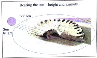
Sun
On a clear day especially during the
summer the sailors could use the sun overhead at
midday to
navigate by. They can use the height of the sun to work out their
latitude.
Clouds
Sea captains observed the clouds over
islands. There is a special cloud formation
which indicates there is land close
by.
Using wildlife
Seaweed
Sailors often saw seaweed in the sea
and could tell by the colour and smell how long it
had been
them. If it was fresh and smelled strongly,then the ship was close
to land.
Birds
Sea birds could be used to show the
way to land when it was nowhere to be seen. In
the evening nesting birds return to land and their nests. So seamen
could follow the birds to land even
if they were offshore and in the open
sea.
Using the weather
Fog
Fog gathers at sea as well as over streams or rivers.
Seamen used it to help identify the position of a stream or river
when they were close to land.
Winds
Wise seamen used the winds to direct their sailing. They
could accelerate the speed, but they could also be dangerous. So
the Vikings would observe the winds before and during their
outward or return
journeys.
Using the sea
Certain tides and
currents could be used by skillful sailors to carry ships to their
destination.These skills helped
sailors explore the seas and discover new lands. They increased
their ability to navigate new seas when they used
instruments.
Page 2:
Using navigational instruments to
help
Finding
longitude
There was no
secure method of measuring longitude until the
17th century when the British solved this theoretical problem.
Nobody knew that the earth moved westwards 15
degrees every hour, but sailors did know
an approximate method of calculating longitude using
speed and time. An early method of measuring speed
involved throwing a knotted rope tied to a log
over the side of the ship. The rope
was tied to a log which was then thrown into the sea.
As the ship advanced through the water
the knots were counted as they passed through a seaman's hands. The
number of knots that were counted during a fixed period of time
gave the speed of the ship in nautical miles per
hour.
Later, when seamen began to use the
compass in the 12th century they could calculate
longitude using
complicated mathematical tables. The compass has a special
magnetic pointer which
always indicates the North Pole, so
it is used to help find the direction that the ship needs
to go. In this way the ship could set a
straight course even in the middle of the
ocean.
Finding latitude
The Bearing
Circle
It was the first instrument to
measure the sun's position. A seaman would measure the
sun's shadow
and compare it with the height of the sun at midday. Then he could
tell if he was sailing on his correct rather than a random
course.
A Bearing Circle
The
Astrolabe
The astrolabe, quadrant and sextant
are all connected. They are developments of
one another. The earliest, the astrolabe, was a special all-in-one
tool for telling the position of the
ship in relation to the sun and
various stars which covered the whole sky. This gave
the seamen
the local time and allowed them to find their latitude at sea.
However, it was awkward
to use as one of the points of
reference was the moving ship
itself.
The
Quadrant
This was a more
precise and simplified version of
the astrolabe. It measured how high
stars were above the horizon using a quarter circle
rather than the full circle of the
astrolabe.It was easier to handle because it was more
portable. Its shortcoming was that it still
used the
moving ship as one of the fixed points of reference. As the ship
rose and plunged in the waves,
it was extremely difficult to be accurate with any
reading.
The
sextant
The sextant was the updated version
of the astrolabe and quadrant which reduced
the tendency to make
mistakes. It proved to be the most accurate and
reliable of these early navigational instruments. It works
by measuring the angle between two fixed objects
outside the ship using two mirrors. This
made the calculations more precise and easier to
do.
p.17
THE GREATEST NAVIGATIONAL JOURNEY:A LESSON IN
SURVIVAL
I am proud to have sailed with Captain Bligh on
his journey of over 40 days through about
4,000miles in an open boat across the Pacific Ocean in
1789. Our outward voyage in the "Bounty" to
Tahiti had been
filled with the kind of incidents that I thought
would be my stories when I returned home. But how wrong I was! On
our departure from Tahiti, some of the
crew took over the ship.They
deposited the captain into a small boat to let him
find his own way home. But who else was to go with him? Those of us
on board the "Bounty" were caught in a dilemma.
Was it better to risk certain death by sitting close together on a
small, crowded open boat with very little food and water? Or should
one stay on the "Bounty" with the crew and face certain death from
the British Navy if caught? The drawback of staying on the ship
seemed to grow as I thought about how wrong it was to treat Captain
Bligh in this way. So I joined him in the small boat. As
dusk fell, we seemed to face an uncertain future.
We had no charts and the only instruments the captain was allowed
to take with him were a compass and a quadrant.http://www.tingroom.com/upimg/allimg/091013/064601J32-0.jpgSailing the Oceans 课堂教学设计" />
Once we were at sea, our routine every day
was the same. At sunrise and sunset the
captain measured our position using
the quadrant and set the course
using the compass. It was extremely difficult for us to get a
correct reading from the quadrant as the boat moved constantly. The
captain used a system called "dead reckoning". He knew there was
land directly northwest of our original position. So his task was
to make sure we stayed on that course. As you can see from the map
we kept to a straight course pretty well. In addition, the captain
kept us all busy reading the
tables to work out our position. Although
this took a great deal of time, it
didn't matter. Time was,
after all, what we had a lot
of!
Our daily food was shared
equally among us all: one piece of bread and one cup
of water. It
was starvation quantities but the extreme lack of water was the
hardest to cope
with
psychologically. Imagine
all that water around you, but none of it was safe to
drink because the
salt in it would drive you mad! All the time the captain tried to
preserve our
good spirits by telling
stories and talking hopefully about what we would do when we
got back to
England. We only half believed
him.
The tension in the
boat got worse as the supply of food and water
gradually disappeared. We could
foresee that we would die if we could not reach
land very soon and we sank gradually into a sleepy, half-alive
state. The captain was as weak as the rest of us, but he was
determined not to give up. He continued his navigational
measurements every day. He kept us busy and tried to take our minds
off our stomachs and our thirst. He kept us
alive.
You could not imagine a more disturbing sight
than what we looked like when arriving
in Timor over forty days after being
set loose in our small boat. Our clothes were
torn, we had
fever and our faces showed the hardships we had
suffered. But after a rest, some good meals
and some new clothes, everything
changed. We couldn't stop talking about our voyage
and everybody wanted to hear about it. We were the heroes who had
escaped the jaws of death by
completing the greatest navigational
feat of all time!
加载中,请稍候......
 加载中…
加载中…
